Man braucht für die 72 km natürlich nicht fast 14 Tage; normalerweise reichen dafür problemlos 6 Tage. Warum ich 14 Tage gebraucht habe? Ganz einfach! Ich hatte nach einer Möglichkeit gesucht mehr als eine Woche unterwegs zu sein, da die gesamten Fixkosten wie Flug usw. einfach unverhältnismäßig hoch waren (bei den heutigen Flugpreisen umsomehr!). Da Dave Beck, der in den siebziger Jahren diese Tour als erster erkundet und durchgeführt hat, eine Kombination von 6 Tagen in einem Basecamp (Tyndall High Camp) und die anschließende Durchquerung zu einem interessanten Preis anbietet, habe ich zugegriffen.
Vom Trailhead beim Symmes Creek hat man einen guten Blick über die aride Hochwüste, die östlich der Sierra liegt. Von hier geht es erst mal anderthalb Tage mit den Skiern auf dem Rucksack aufwärts. Da wir keine Eile hatten, haben wir nach dem ersten Tag ein Couloir (The Superbowl) erstiegen und abgefahren. Dann ging es weiter über Anvil Camp und The Pothole bevor wir den Anstieg zum Shepherd Pass erreichten. Zwischendurch konnten wir kurz die Schi anlegen, für den Anstieg zum Pass mussten sie dann jedoch wieder auf den Rucksack.
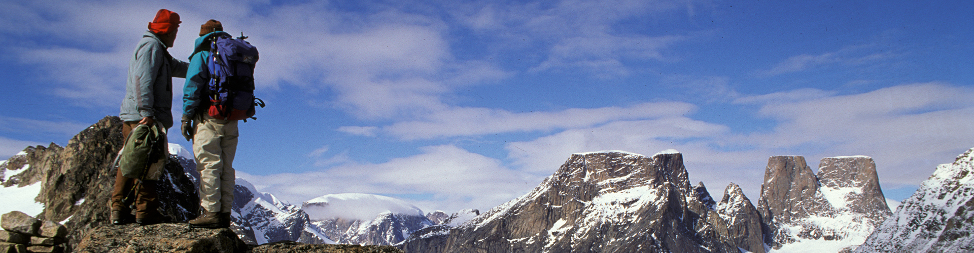
Auf der Passhöhe betritt man dan den Sequoia NP. Kurz nach der Passhöhe, Mount Tyndall in bester Sicht, schlugen wir dann unser Basislager auf. Von hier aus haben wir dann einige Tagestouren unternommen, darunter auch einen Besteigungsversuch des Mount Tyndall. Dieser musste jedoch auf ca. 4000 m wegen Schlechtwetters abgebrochen werden. Die Gegend ist beeindruckend. Ringsum alles 4000er und bis auf knapp 3600 m wachsen die Bäume. Ansonsten alles Stein und Schnee.
Fragt ein Tourist einen Führer, woher all die Steine herkommen. Antwortet der Führer, die hätten die Gletscher gebracht. Daraufhin der Tourist: "Welche Gletscher? Ich sehe keine". Die trockene Anwort: "Gone for new rocks".
Später verlegten wir das Lagers etwas weiter nach unten und Westen. Nach insgesamt einer Woche (gerechnet vom Start) ging es los. Das erste Zwischenziel war von Anfang an in Sicht, nämlich Milestone Mountain mit dem Paß Milestone Col auf fast 4000 m. Der Berg mit der unverkennbaren Spitze in Form einer Nadel ist wirklich wie ein Meilenstein. Die letzen Meter zum Pass mussten mit den Schi am Rücken zurückgelegt werden. Die nächsten Tage geht es dann immer wieder über Pässe mit dazwischen liegenden Abfahrten (Triple Divide Pass, Coppermine Pass, Shark Fin Pass).
Die letzte Übernachtung wurde auf den Tablelands am Ufer eines zugefrorenen Sees vorgenommen. Am nächsten Tag ging es dann über den "Hump" zum Ziel, einem Parkplatz im Sequoia NP. Die letzten paar Meter mussten dann wieder zu Fuß mit den Schi am Rücken zurückgelegt werden. Bei der Rückfahrt (die Frau von Dave hat mit einem Kleinbus auf uns gewartet) konnten dann die namengebenden Riesenbäume des Nationalparks betrachtet werden. Die Tour klang dann mit dem ersten nicht selbst gekochten Abendessen in zwei Wochen standesgemäß aus. War übrigens die längste zusammenhängende Zeit, die ich im Zelt verbracht habe, nämlich 14 Tage am Stück!
Alles in allem eine tolle Tour. Voraussetzung ist jedoch, dass man erstens nicht dauernd schönes Wetter erwartet (es gab fast jeden Tag kurze Schneefälle, aber auch Sonne und blauen Himmel), zweitens bereit ist auf etwas Komfort zu verzichten und drittens die Tour nicht wegen des Schifahrens macht, da Rucksack und wechselnde Schneeverhältnisse das schifahrerische Vergnügen etwas mindern. Empfehlenswert sind auch eingegangene Schischuhe, sonst kann die Tour zur Quälerei ausarten. Siehe Bildgalerie!
Nachstehend die Beschreibung aus dem Führer von John Moynier:
Sierra High Route
Highlights: Justifiably the most famous ski tour in the range.
Difficulty: Class 3-4
Distance: About 45 miles
Trailheads: Symmes Creek and Wolverton Ski Area
USGS 15' Maps: Mount Whitney, Triple Divide Peak
USGS 7.5' Maps: Mount Williamson, Mount Brewer, Mount Kaweah, Triple Divide Peak, Lodgepole
Overview:
This classic trans-Sierra tour is goal of most Sierra backcountry skiers. The Sierra High Route has everything, wonderful high traverses, great ski descents, spectacular scenery, and exciting mountaineering challenges. This tour, which justifiably ranks as one of the finest ski tours in the world, enjoys a rich history. A variation of this route was done in the early 1930s, but the classic route was first done by pioneering guides David and Susan Beck in the mid-1970s. Over the past 20 years, the High Route has become very popular. The route basically follows the boundary between Sequoia and Kings Canyon national parks along the divide between the Kings, Kern, and Kaweah rivers. Starting in the high desert, the route quickly rises to over 12,000 feet and stays above 11,000 feet for most of the tour before dropping into the giant sequoias on the west side. There are tremendous views all along the route, but especially in Cloud and Deadman canyons. Route: The route begins in the high desert at the trailhead at Symmes Creek (6,300'). You more of less follow the summer trail up steep switchbacks over a saddle (9,400') and into the drainage of Shepherd Creek. The trail traverses down across a steep, sandy slope before reaching the creek at Mahogany Flat (9,000'). From here, the route follows the creek up past Anvil Camp (10,000') and The Pothole (10,800') before reaching the moraine below Shepherd Pass. The final slope up to the pass (12,000') is quite steep and can be avalanche-prone. Beware. At the pass, you enter Sequoia National Park. A gentle descent from the pass brings you out onto the open, sparsely timbered slopes of Tyndall Plateau (11,700'). Contour around the toe of Diamond Mesa, then head west toward the low saddle (11,500') at the end of the ridge trending south from Lake South America. From here, drop down steep, forested benches to the small lakes near the head of Kern River Canyon (10,650'). For an alternate start to the tour, begin at Onion Valley (9,200'). This route leads over Kearsarge Pass (11,800') and down past Bullfrog Lake (10,600') to Bubbs Creek Trail at Vidette Meadows (8,300'). From here, you can ski up Vidette Creek Canyon past the Vidette Lakes (10,500') to Deerhorn Saddle (12,600'), where you can look across the Ericsson Lakes (11,800') cirque to the steep climbs leading over Harrison Pass (12,800') or Ericsson Pass (12,600') to the Kern River and the High Route. This start begins at a higher trailhead and adds some very wild terrain. From the Kern, follow the course of Milestone Creek up into beautiful Milestone Basin (11,200'). To the east, the 14,000-foot summits of Mount Langley, Mount Muir, Mount Whitney, Mount Russell, Mount Tyndall, and Mount Williamson line the crest and preside over the canyon of the Kern. To the west, at the head of the basin, locate the sharp granite spire of Mile stone Peak. Use this slender finger of rock as a landmark as you climb up talus slopes, then, just below the summit, traverse left across a steep slope to Milestone Pass (13,000'). This traverse is pretty spooky because it skirts the top of a big cliff and can be icy. From the pass, a wonderful descent brings you down Milestone Bowl to the creek (11,200') below Colby Pass. The route then tackles the next pass, which is more of a steep ridge cross ing. Climb very steeply above cliffs to the summit of the prominent ridge (12,000') trending south from Colby Pass. The views south are dominated by the imposing Kaweah peaks, especially the dark mass of Black Kaweah. The route then takes a long traverse above the headwaters of Kaweah River to Triple Divide Pass (12,200'), crossing into Kings Canyon National Park just north of Triple Divide Peak. If avalanche danger is high, it' s better to skip the traverse and drop down to the river before climbing back up to ward Triple Divide Pass. From the pass, another great downhill run takes you west to Glacier Lake (11,6501). A very steep traverse leads south around to the head of Cloud Canyon, passing just below Lion Lake Pass. Staying on the Cloud Canyon side of the divide, make a long, sweeping traverse up the slope toward Glacier Divide. As you gain altitude, the peaks of Great Western Divide become visible over the prominent spine of The Whaleback. A short, steep climb accesses the top of the ridge just north of its junction with the main crest at Coppermine Pass (12,100'). Although the ridge is very exposed, camping on the spectacular ridge is highly recommended. A short, steep gully on the west side of the pass brings you down into the equally sublime Deadman Canyon (11,600'). A slightly downhill traverse below Elizabeth Pass takes you to the obviously named Fin Pass (11,300') and back into Sequoia Park at Lonely Lake (10,800'). Spectacular views to the south, including the tops of Angel Wings and Hamilton Dome, accompany the route as it crosses over a low ridge (11,200') into the head of Buck Canyon. A convoluted traverse finally brings you to The Tablelands (11,000') and the long, remarkable downhill run to Pear Lake Hut (9,200'). The hut, which is manned by winter rangers, is available for overnight stays with advance reservations. The route out from the hut is marked and skirts the slabs near Aster and Heather lakes before climbing over The Hump (9,400'), dropping down through the trees, and following Wolverton Creek to the trailhead at Wolverton Ski Area (7,300'). For an even more memorable ending, follow the marked ski trail over the ridge and down through the awe-inspiring giant sequoias to Giant Forest.